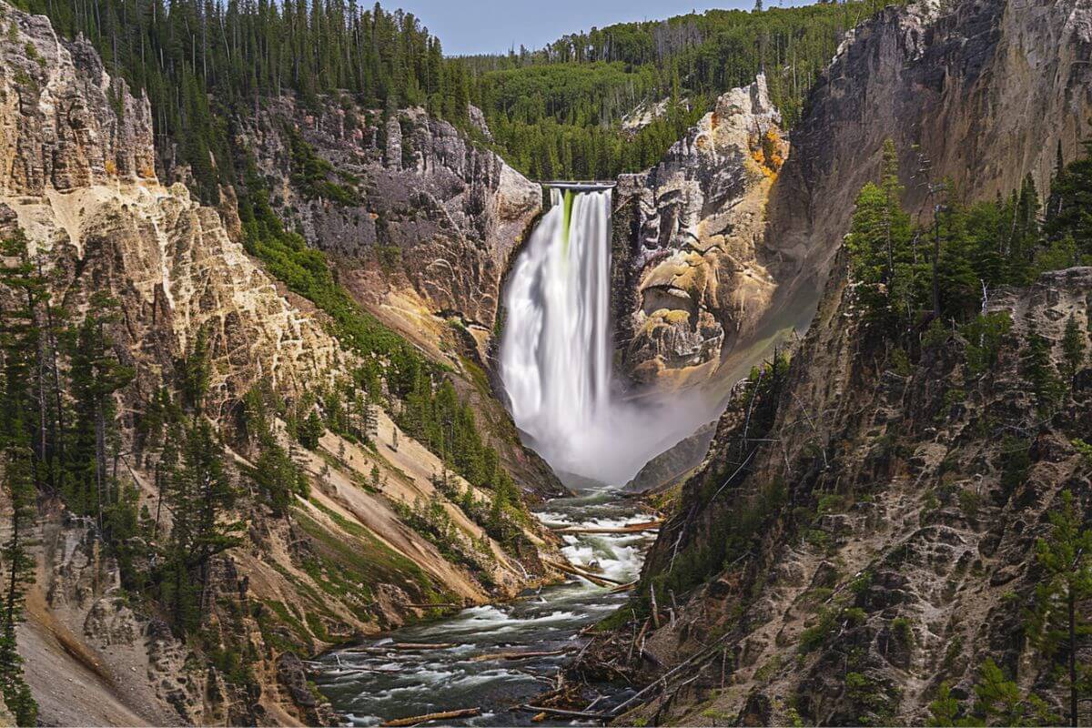
Lower Falls in Montana is a breathtaking natural gem, standing tall at 308 feet (93.8 meters) and renowned as the most famous waterfall in Yellowstone National Park. Nestled at the head of the Grand Canyon of the Yellowstone River, it’s a powerful force of nature with a significant water volume, making it a must-see for nature lovers.
I’ll guide you through the beauty of Lower Falls and the surrounding area, including the trails that offer unique perspectives of the falls and canyon. We’ll explore how to access this majestic site and the best times to visit for an unforgettable experience.
- Related article: Waterfalls in the Treasure State
Ever wondered what makes Lower Falls such a popular spot in Yellowstone? The answer lies in its grandeur and the variety of trails that lead to stunning viewpoints. Let’s discover more about this natural wonder and how you can make the most of your visit.
7 Key Takeaways on Lower Falls
- Lower Falls in Yellowstone National Park is the most famous waterfall, standing at 308 feet and offering a powerful display of nature’s beauty and force.
- The Grand Canyon of the Yellowstone River, where Lower Falls is located, stretches 24 miles and features depths up to 1,200 feet, showcasing a landscape shaped by centuries of erosion.
- Trails near Lower Falls cater to all levels of hikers, providing various vantage points of the falls and the canyon, with options like the Brink of the Lower Falls Trail and the 19-mile loop including Upper Falls and Artist’s Point.
- Directions to Lower Falls offer different paths, such as the steep descent of the Brink of the Lower Falls Trail and the scenic North Rim Trail, providing unique perspectives of the falls and the canyon.
- Lower Falls is easily accessible from Canyon Village and is best visited in spring, summer, or fall for clear trails and pleasant weather, with winter visits possible via snow coach tours for a different experience.
- The falls, surrounded by vibrant colors, dramatic cliffs, and wildlife, are not just a stunning natural feature but also a reminder of the Earth’s raw power, enhanced by hydrothermal elements in the canyon.
- Lower Falls is a timeless symbol of nature’s beauty and strength, offering breathtaking views from various points like the Brink of the Lower Falls Trail and Inspiration Point, ensuring a memorable and inspiring visit for all.
About Lower Falls
| Location Coordinates | Height | Nearby Features | Location |
|---|---|---|---|
| 48.93551° N, 115.68157° W | 308 feet (93.8 meters) | Yellowstone River | Backcountry, Glacier National Park, Glacier County, Montana |
Lower Falls, Montana, holds a special place as the most famous waterfall in Yellowstone National Park. Standing tall at 308 feet (93.8 meters), it’s a majestic sight to behold. This natural gem is not just a beauty but also boasts a significant water volume, making it a powerful force of nature.
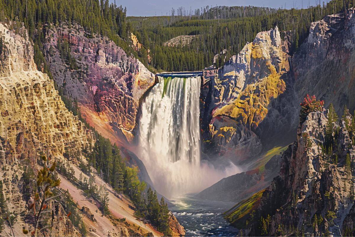
Located at the head of the Grand Canyon of the Yellowstone River, Lower Falls is part of a geological wonder that stretches approximately 24 miles (39 km) long.
The canyon is no less impressive, with depths ranging between 800 and 1,200 feet (240 and 370 meters) and a width that varies from 0.25 to 0.75 miles (0.40 to 1.21 km).
The formation of the Grand Canyon of Yellowstone is a tale of the enduring power of erosion, shaped over centuries by the relentless flow of the Yellowstone River.
This process has created a landscape of dramatic colors and shapes that captivate all who visit. The canyon also features hydrothermal elements like steam vents and hot springs, adding to its unique allure.
Lower Falls itself is the largest waterfall in Yellowstone National Park and the second most photographed spot in the park, following the iconic Old Faithful Geyser.
Visitors are treated not only to the breathtaking cascade but also to the canyon’s other features, including precipitous jagged cliffs and a rich array of wildlife. The rocks in the canyon are a mesmerizing palette of colors, further enhancing the scenic beauty of the area.
Directions to the Falls
To get to Lower Falls in Yellowstone National Park, you have a few different paths to choose from. Each one offers a unique perspective on this natural wonder:
- Brink of the Lower Falls Trail – This trail is a thrilling way to see the falls up close. It’s a steep descent of 600 feet (182.8 meters) in less than half a mile. To start this adventure, head south from Canyon Village and turn left onto the North Rim Drive. The parking area is on your right.
- Inspiration Point – For a photographer’s dream view, head to Inspiration Point at the far end of the canyon. Drive out on the North Rim Drive and take your last right to reach this picturesque spot.
- North Rim Trail – This trail runs along the North Rim Drive before branching off towards Inspiration Point. It’s a 3.8-mile (6.1 km) scenic route one way.
- Uncle Tom’s Trail – Another steep trail, Uncle Tom’s Trail, leads to the river’s edge for a unique view of the falls. Park at Uncle Tom’s Point to start this adventure.
- Artist Point – To reach Artist Point, a favorite spot for photographers, take the South Rim Trail.
Lower Falls is easily accessible just south of Canyon Village, visible from both the North Rim and South Rim Drives. The best time to visit is in the spring, summer, or fall when trails are clear and the weather is pleasant.
In winter, you can still enjoy the falls through snow coach tours, adding a new dimension to your Yellowstone experience.
Trails Near Lowers Falls
Montana’s Lower Falls area is a treasure trove of trails, each offering a unique perspective of the natural beauty that surrounds it. Here’s a quick look at the variety of trails near Lower Falls and what they have to offer:
| Name | Length | Description |
|---|---|---|
| Brink of the Lower Falls Trail | 0.7 miles (1.1 km) | This moderately challenging 0.7-mile (1.1 km) out-and-back trail provides a close-up view of the Lower Falls. |
| Brink of Lower Falls via North Rim Trail | A short hike from the parking area offers a viewpoint for photographers. | This moderately challenging 2.3-mile (3.7 km) out-and-back trail offers a different perspective of the Lower Falls. |
| Clear Lake and Artist’s Point Loop Trail | 0.81 mile (1.3 km) | This scenic 0.81-mile (1.3 km) loop provides a view of Clear Lake and Artist’s Point. |
| North Rim Trail | 3.8 miles (6.1 km) | This 3.8-mile (6.1 km) one-way trail offers views of the North Rim of the canyon, Inspiration Point, and the North Rim Drive. |
| Uncle Tom’s Trail | 0.7 miles (1.1 km) | This steep 0.7-mile (1.1 km) one-way trail leads to a viewpoint near the edge of the river, providing a unique perspective. |
| Artist Point | 0.2 mile (0.32 km) | A short hike from the parking area offering a viewpoint for photographers. |
| Lookout Point | Roughly 2 miles (3.2 km) | Located approximately 2 miles (3.2 km) from the Cannon Village. |
| Inspiration Point | 5.7 mi (9.2 km) | Located at the far end of the canyon, offers one of the most photographed viewpoints. |
| South Rim to Ribbon Lake Loop | 7.3 miles (11.7 km) | This 7.3-mile (11.7 km) loop provides a scenic view of the South Rim of the canyon and Ribbon Lake. |
| Clear Lake and Artist’s Point Loop | 1.3 miles (2.1 km) | This 1.3-mile (2.1 km) loop offers a view of Clear Lake and Artist’s Point from the Wapiti Lake Trailhead. |
| Canyon Rim South Trail to Point Sublime | 6.8 miles (10.9 km) | This 6.8-mile (10.9 km) loop provides a scenic view of the South Rim of the canyon and Point Sublime. |
| Upper Falls, Lower Falls, and Artist’s Point | 19.0 miles (30.6 km) | This 19.0-mile (30.6 km) loop offers a view of the Upper Falls, Lower Falls, and Artist’s Point. |
| Red Rock Point via Red Point Trail | 4.3 miles (6.9 km) | This 4.3-mile (6.9 km) loop provides a scenic view of the North Rim of the canyon and Red Rock Point. |
These trails not only offer a range of experiences, but they also provide different vantage points of the Lower Falls and the Grand Canyon of the Yellowstone River. It’s a great way to truly appreciate the majesty of this natural gem from various angles and elevations.
Lower Falls Final Thoughts
Lower Falls in Yellowstone National Park stands as the pinnacle of its natural marvels. This 308-foot (93.8-meter) cascade isn’t just any waterfall; it’s a mesmerizing masterpiece, captivating all who behold it with its sheer volume and grandeur.
Perched atop the Grand Canyon of the Yellowstone River, Lower Falls offers a breathtaking display of nature’s beauty. Surrounding trails cater to all, from leisurely strolls to challenging hikes, each unveiling a distinct view of the falls and canyon.
Immersing oneself in the canyon’s vibrant colors, towering cliffs, and bustling wildlife is an experience like no other. The presence of hydrothermal features adds an extra layer of wonder, showcasing Earth’s raw power in a single location.
For those seeking different perspectives, the Brink of the Lower Falls Trail and Inspiration Point offer not just beautiful, but truly incredible views. Whether from the North Rim or South Rim Drives, visitors can find their perfect spot to witness Lower Falls’ majesty.
Regardless of the season, Lower Falls promises an unforgettable experience, making it a must-see for anyone seeking to connect deeply with the natural world and draw inspiration from its splendor.
Lower Falls FAQs
1. How Tall Is Lower Falls?
Lower Falls stands at a height of 308 feet (93.8 meters), making it one of the most impressive waterfalls in Yellowstone National Park.
2. What Are the Best Trails to View Lower Falls?
Some popular trails for viewing Lower Falls include the Brink of the Lower Falls Trail, the Brink of Lower Falls via North Rim Trail, and Uncle Tom’s Trail.
3. When Is the Best Time to Visit Lower Falls?
The best time to visit Lower Falls is during the spring, summer, or fall seasons when weather conditions are favorable for hiking and sightseeing. Snowcoach tours also offer access to the falls in winter.
Captivated by the beauty of Montana? Check out these interesting reads for an enriching exploration of the state: